| Mars Global Surveyor Orbiter Camera |
 Original 54kB tif
 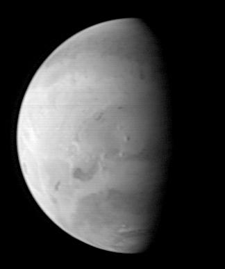 Original Caption Released with Image: 01
This Mars Orbiter Camera (MOC) picture shows the Elysium region of Mars as it appeared from the Mars Global Surveyor (MGS) spacecraft on on August 20, 1997. At the time, MGS was 5.57 million kilometers (3.46 million miles) and 22 days from Mars, and the picture has a resolution is about 20.8 km per picture element. Mars, 6800 km (4200 mile) in diameter, is about 327 pixels across. North is at the top of the image. The camera was pointed at the center of the planet (near the dark, morning sunrise line, or terminator) at 23.6üŗ N, 217.4üŗ W. At this distance from Mars, only atmospheric phenomena (clouds and fogs) and bright and dark markings resulting from variations in the amount and thickness of dust and sand are usually visible. However, in this view the shading of the relief of the three Elysium volcanoes (from north to south Hector Tholus, Elysium Mons, and Albor Tholus) can be seen owing to their position close to the terminator. Elysium Mons, the center-most volcano, is estimated to be 12,000-14,000 meters (39,000 to 46,000 feet) high.
Mars Global Surveyor has been enroute to Mars since November 7, 1996 and arrives there on Thursday, September 11 around 6:30 PM PDT. The spacecraft will use atmospheric drag to reduce the size of its orbit, and will begin mapping operations in March 1998.
Malin Space Science Systems and the California Institute of Technology were responsible for development of the Mars Observer and Mars Global Surveyor cameras. MSSS operates the MOC from its facilities in San Diego, CA, under contract to the Jet Propulsion Laboratory.
Image Note:
Photo Credit: NASA/JPL/Malin Space Science Systems
MOC2-4
83495 082297_3 elysium.gif 556557746.51
South up image
Original 54kB tif 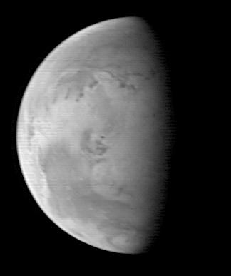 The Mars Orbiter Camera (MOC) took this image on August 20, 1997, when the Mars Global Surveyor (MGS) was 5.67 million kilometers (3.52 million miles) and 22 days from entering orbit. At this distance, the MOC's resolution is about 21.2 km per picture element, and the 6800 km (4200 mile) diameter planet is about 327 pixels across. North is at the top of the image. The MGS spacecraft pointed the camera at the center of the planet (near the dark, morning sunrise line, or terminator) at 23.6üŗ N, 82.1üŗ W. At this distance from Mars, only bright and dark markings resulting from variations in the amount and thickness of dust and sand are visible. The large dark marking stretching from the right center northward is Acidalia Planitia, a region of rock and sand with less dust on it than the area immediately to the south, Chryse Planitia. Both Viking Lander 1 and Pathfinder landed in the latter, bright area. In this low resolution image, some of the dark features resemble the "canals" seen prominently in maps created by astronomers of the 19th and early 20th century. Mariner 9 and Viking images show that most of these dark lines are associated with sand deposits that are trapped in rough areas.
 Mars Global Surveyor was launched on November 7, 1996 and will enter Mars orbit on Thursday, September 11 around 6:30 PM PDT. The spacecraft will use atmospheric drag to reduce the size of its orbit. Mapping operations will begin in March 1998.
The MOC on MGS is a spare camera originally developed for the ill-fated Mars Observer mission. Malin Space Science Systems and the California Institute of Technology were responsible for development of both cameras. MSSS operates the MOC from its facilities in San Diego, CA, under contract to the Jet Propulsion Laboratory.
Image Note:
Photo Credit: NASA/JPL/Malin Space Science Systems
MOC2-3
83494 082297_2 chryse.gif 556524446.41
South up image
Original 54kB tif 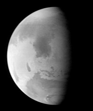 This image was acquired by the Mars Global Surveyor (MGS) Mars Orbiter Camera (MOC) on August 20, 1997, when MGS was 5.51 million kilometers (3.42 million miles) and 22 days from encounter. At this distance, the MOC's resolution is about 20.6 km per picture element, and the 6800 km (4200 mile) diameter planet is about 330 pixels across. North is at the top of the image. The MGS spacecraft pointed the camera at the center of the planet (near the dark, morning sunrise line, or terminator) at 23.6üŗ N, 307.3üŗ W. The irregularity of the terminator seen in this image results from contrast processing. This image shows the prominent dark feature Syrtis Major, believed to be a relatively dust-free area of bedrock outcrop and sand dunes. The large Hellas impact basin (2000 km or 1250 miles across) is seen at the bottom of the picture. Clouds from the south polar region fill the basin. The north polar residual ice cap, surrounded by a dark annulus of sand, is seen at the top of the picture.
 Launched on November 7, 1996, Mars Global Surveyor will enter Mars orbit on Thursday, September 11 around 6:30 PM PDT. After Mars Orbit Insertion, the spacecraft will use atmospheric drag to reduce the size of its orbit, achieving a circular orbit only 400 km (248 mi) above the surface in March 1998, when mapping operations will begin. At that time, MOC narrow angle images will be 14,000 times higher resolution than this picture, and global wide angle images will be 3 times better.
Malin Space Science Systems and the California Institute of Technology built the MOC using spare hardware from the Mars Observer mission. MSSS operates the camera from its facilities in San Diego, CA. The Jet Propulsion Laboratory operates the Mars Global Surveyor spacecraft with its industrial partner, Lockheed Martin Astronautics, from facilities in Pasadena, CA and Denver, CO.
Image Note:
Photo Credit: NASA/JPL/Malin Space Science Systems
MOC2-2
83493 082297_1 syrtis.gif 556579886.61
[NASA/JPL/Space Science Institute]
 ALPO-Japan Latest ALPO-Japan Latest
 Mars Section
1997/09/10
| 1997/07/04
| |